Here are some of the things that you will able to enjoy as you hike the Kettle Creek Battlefield

Hiking Trails
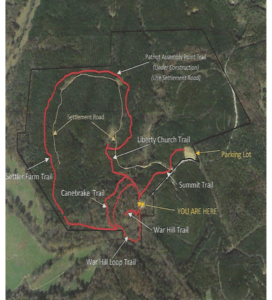
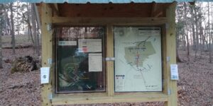
Trail maps and informational pamphlets are available at the kiosk located next to the War Hill parking area.

Revolutionary War Soldier Graves Search
Over the past several years the Kettle Creek Battlefield Association has conducted several archaeological studies of the Kettle Creek Battlefield in order to better understand where the battle occurred. With help of the Lamar Institute, Southeastern Archaeological Services and Lakehead Paleo University the studies used a variety of archealogical methods. Archaeologist searched the area with metal detectors, cadaver dogs, ground penetrating radar, LIDAR and culminated with the actual opening of several grave sites. The result revealed that the fallen solider were buried in shallow graves through the battlefield from the beginning atop Liberty Church Hill, through the Kelly Branch valley around War Hill and completing with the surrender. These efforts revealed 27 probable grave sites which were marked with white crosses around the battlefield. We invite you to search for these crosses to see how the battle progressed by the location of the fallen.
Below you will find a Kettle Creek Battlefield graves location map and corresponding form with helpful hint to locate the crosses. Print these items for use as you visit the battlefield. Let us know how many white crosses you find by emailing the Kettle Creek Battlefield Association.
If you are able to locate more than 20 of the white crosses you will receive a prize.
Attach a picture with a Revolutionary War Soldier grave marker.
Contact us at: